EARTHQUAKE AND TSUNAMI OF 13 AUGUST 1868 IN ARICA, PERU
George Pararas-Carayannis
INTRODUCTION
On August 13, 1868 a great earthquake in the offshore area near Arica, Peru (at that time) generated a Pacific-wide tsunami. Locally, the disaster caused extensive damage to villages and towns alog the coast of Southern Peru and Northern Chile and killed hundreds of people in the immediate region. Tsunami waves caused extensive destruction to coastal towns and ports along the coast of Peru and Northern Chile. Iquique, Mejillones, Tocopilla, Coquimbo, Constitución, Tomé, Concepción, Talcahuano, Coronel and other towns and villages were particularly damaged. The historical records and literature pertaining to this event were thoroughly examined by Iida, Cox and Pararas-Carayannis in their catalog of Tsunamis in the Pacific (1967) in an effort to reconcile differerences in reported dates, tsunami travel and heights and events related to the near and far-field effects of the tsunami.
THE EARTHQUAKE
Date and Origin Time - About 17:15 (local time) on Aufust 13, 1868.
Magnitude - 8.5 Richter scale (Reconstructed estimate)
Epicenter - 18.05 South, 71.? West at sea about 70 km from Arica.
Focal depth - Shallow
Aftershocks - There were no instrumental recordings at that time but it was reported that several strong aftershocks occurred in the following hours, days, weeks and months.
Ground Motions - According to eyewitness reports the ground motions lasted four to five minutes. However, this seems rather long, so there is a possibility that the reports did not distinguish between the main shock and the stong aftershcoks that followed.
Death Toll and Damages - The historical accounts of the death toll from this event differ significantly. According to Milne (1915) the tsunami caused 25,000 deaths. It is not clear how he arrived at this estimate. Locally, there was extensive loss of life and destruction in the upper part of the city (Arica) from the earthquake. There was extensive destruction by the tsunami of the lower part of the city. It is estimated that between 300 to 350 people lost their lives in Arica - a city with city population of 10,000 at the time.

THE TSUNAMI
Bothe Near and Far-field effects of the1868 tsunami are summarized in the Table at another section. Height are based on either instrumental recordings by tide stations or on visual observations of runup measurements.
NEAR-FIELD EFFECTS - Locally, tsunami waves of as much 14 meters in height caused extensive destruction to coastal towns and ports along the coasts of Southern Peru and Northern Chile (Morales and Canon, 1985). As stated, there was extensive destruction at Iquique, Mejillones, Tocopilla, Coquimbo, Constitución, Tomé, Concepción, Talcahuano, Coronel and other locations (Iida et al., 1967).
There was severe damage at Arica. The first sea level fluctuation was a withdrawal of the sea 22 minutes after the earthquake. Ships in the harbor sat on the bottom. Two subsequent waves crushed on the port's wharf - the first sweeping the people who were providing aid to the crew of beached ships. These two waves had an estimated runup of 10 meters. Approximately two hours later, at 19:10 (local time), two more waves appeared like water walls of about 14 meters in height and struck violently the coastal area of Arica, spreading widespread destruction up to the elevation where the First Church of Arica (later renamed Church of San Marcos) was located. The reports on maximum tsunami wave height differ. Montessus de Ballore (1907) refers to a report by Schmick (1879) of a 21 m. runup at San Pedro. Gutenberg andRichter (1959) give the reported height as 18 m. and indicate it is most probably a mistake. However, the 14 m maximum wave at Arica is well documented. Oscillations in the harbor continued for three days.

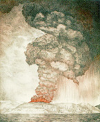
Artistic Rendering of the 1868 Tsunami in Arica (then city of Peru)
IMPACT OF TSUNAMI ON SHIPS IN ARICA
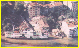
There were several ships anchored offshore near Arica at the time. Two were US Navy ships - the USS Fredonia and the USS Wateree. These two ships had moved to Arica from Callao, Peru, because, at the time, there were reported cases of yellow fever. When the tsunami occurred and the water first withdrew, the USS Fredonia sat on the bottom. Maximum wave, 2 hr after the quake, wrecked most ships in harbor. The wave completely demolished the Fredonia and drowned twenty-seven of its officers and men. Only three of the officers - who were on shore - survived and only two of the total crew were rescued from the sea. Two other ships, the Peruvian corvette America and the English bark Chanarcillo were also destroyed and many of their sailors drowned. The boats were carried about 300 m. inland.
In terms of lives lost by the impact of the 1868 tsunami, the USS “Wateree” fared much better. The ship's design of a flat bottom, with wheels on both sides and double rudders in the bow and stern, gave the ship stability which prevented its breaching - thus saving the crew from harm. However, the ship was badly damaged and since it was beyond any cost of effective repair, it was sold for its scrap value. All of Wateree's crew survived with the exception of one seaman who was was tending the captain's gig and who was carried out to sea and drowned.
The accounts on how far the USS “Wateree” was dragged inland by the 1868 tsunami difer and are somewhat misleading or eroneous. According to one account, the USS “Wateree” was dragged about 3km inland and deposited at what is now known as "Chinchorro" beach at the foot of Cerro Chuño (a coastal hill). However, another account states that a subsequent tsunami in 1877 refloated the ship and deposited approximately 7.4 km in a northeast direction and beached about 1850 meters away of the coastline. This account seems to be inaccurate.
There is also an account of events of that day by the captain the USS “Wateree”, U.S. Navy Commander, JAMES H. GILLIS. (See Page on the "Loss of the USS Wateree" with additional photographs of the U.S. Navy Archives). The account by Gillis states that while on the ship he felt a trembling, then heard a rumbling sound from the shore (Taylor, Washington Times). Looking toward the town of Arica, he saw buildings collapsing and realized that the town was impacted by a severe earthquake. Immediately, he ordered the deployment of a second anchor for the ship, then called for his gig and accompanied by the ship's doctor, set out to render assistance.
According to his account, when they reached shore, the water in the harbor was receding rapidly and various small crafs were carried around by stong currents. Shortly afterwards the first tsunami wave arrived and the smaller boats begun to smash against the shore. This first wave rose the USS “Wateree” on its crest. Already, most of the town of Arica lay in ruins and its harbor was filled with debris, lumber, shrubbery, cattle and even railroad cars. The cries of the injured could be heard occasionally over the sound of the wave. After the first wave receded, a second wave arrived. Thee USS Wateree had already paid out nearly 600 feet on each of its two anchor chains, which held. The larger ships in the harbor, including Wateree and Fredonia, appeared to be holding their own. However, around 6:30 that evening, a much larger wave with an estimated crest at more than 40 feet crashed onto the deck of the Wateree and swung violently on its anchors
Gillis reported that the ship begunto drift rapidly seaward, when another wave arrived and swung the vessel violently around. At that time the severe strain on the chains resulted in the break of the starboard chain and the ship begun drifting rapidly towards shore. Subsequently, the Wateree was thrown on its side and continued to be impacted by surging sea. When Gillis returned, the Wateree was resting on a point nearly 500 yards from the high-water mark, some 12 feet above sea level. Fortunately there was only one serious injury of the crew. However, the tsunami wrecked completed the USS Fredonia and 27 members of its crew lost their lives.

US Navy Photograph of the beached boats USS “Wateree” and of the Peruvian corvette “America” in the background (Halftone image, copied from the U.S. Naval Institute "Proceedings", July 1926, page 1323)
FAR-FIELD EFFECTS - There are several errors in the literature regarding the dates of the tsunami . For example, Alexander (1893) gives the date of impact in the Hawaiian islands as August 15, 1868 while other Hawaiian publications erroneously report the year of occurrence as 1871. Richter shows it as occurring on August 8, while Milne (1908) gives a date of August. 11, and Iida as August. 16 (Pararas-Carayannis, 1969). Some authors show dates of August 14 and 15 but these are dates of tsunami observation at distant points, not dates of generation. For example, Alexander 91891) gives the date of the tsunami in the Hawaiian Islands as August 15, 1868 and other Hawaiian publications erroneously report the year of occurrence as 1871 (Pararas-Carayannis, 1969).
Similarly there are many errors in the literature concerning tsunami runup at distant locations. For example, Montessus de Balolore (1907) refers to a report by Schmick (1879) of a 21 m. runup at San Pedro, California. Gutenberg and Richter (1959) give the reported height as 18 m. for San Pedro and indiacate it is most probably a mistake - which it was.
Ths tsunami caused severe damage at Kahului, on the ilsnd of Maui and at Hilo, Island of Hawaii Hawaii where the maximum runup was 4.6 meters and left a mark on a coconut tree. In Kalapana plain 20 acres of land were flooded.
The table below gives a much more accurate accountof far-field tsunami runups. There were significant Pacific-wide effects from the tsunami - which was particularly damaging in New Zealand, Australia, Samoa, Hawaii, San Pedro in California and Japan.
TABLE. NEAR AND FAR-FIELD AMPLITUDES OF THE 13 AUGUST 1868 PERU/CHILE TSUNAMI
The amplitude listed is either a mesasured runup (maximum vertical elevation wave reached above sea level at the time of tsunami) or a zero-to-peak tide gage reading. Both are given in meters.
Location Region Latitude Longitude Amplitude (m) Arrival time (day hr. min. UTC) Travel time (hr. min.)
TOME CHILE 36.63S 72.95W 4.5
TALCAHUANO CHILE 36.67S 73.17W 4.0
COQUIMBO CHILE 29.95S 71.42W 7.5
CALLAO CHILE 12.08S 77.13W 4.0
CONSTITUCION CHILE 35.33S 72.42W 3.5
CORRAL CHILE 39.86S 73.42W 4.0
FERROCARRIL CHILE 0.00N 0.00E 6.0
IQUIQUE CHILE 20.25S 70.13W 12.0
ARICA CHILE 18.48S 70.33W 15.0
JUAN FERNANDEZ ISLAND CHILE 33.00S 80.00W 2.0
VALPARAISO CHILE 33.08S 71.67W OBS.
VALDIVIA CHILE 39.77S 73.25W 5.0
CASMA CHILE 9.50S 78.30W 2.5
MEJILLONES CHILE 23.05S 70.42W 6.0
CHALA HARBOR PERU 15.88S 74.22W 15.0
ISLAY PERU 17.03S 72.10W 12.0
MOLLENDO PERU 17.00S 72.00W OBS.
CALLAO PERU 12.08S 77.13W 4.0
TAMBO PERU 7.58S 78.70W OBS.
TRUJILLO PERU 8.10S 79.00W OBS.
CASMA PERU 9.50S 78.30W 2.5
ACAPULCO MEXICO 16.85N 99.90W OBS.
SAN FRANCISCO CALIFORNIA 37.81N 122.47W 0.2
WILMINGTON BEACH CALIFORNIA 33.76N 118.27W 0.8
SAN PEDRO CALIFORNIA 33.75N 118.29W 0.8
SAN DIEGO CALIFORNIA 32.71N 117.17W 0.3
ASTORIA OREGON 46.21N 123.77W 0.1
KODIAK ALASKA 57.79N 152.41W 2.2
KALAPANA, HAWAII HAWAII 19.35N 154.98W 1.8
HILO, HAWAII HAWAII 19.73N 155.06W 4.5
KAHULUI, MAUI HAWAII 20.90N 156.47W 1.8
KANAIO, MOLOKAI HAWAII 0.00N 0.00E 1.5
HONOLULU, OAHU HAWAII 21.31N 157.87W 1.6
WAIMEA BAY, KAUAI HAWAII 21.95N 159.67W 0.9
RAPA I. TUBUAI IS. 26.80S 144.33W OBS.
APIA SAMOA 13.81S 171.75W 3.0
VITI-LEVU ISLAND FIJI 18.00S 178.00E OBS.
MARQUESAS IS. 9.00S 139.50W OBS.
ANTARCTICA 0.00N 0.00E OBS.
WHITE'S BAY NEW ZEALAND 0.00N 0.00E OBS.
NELSON PORT NEW ZEALAND 41.28S 173.28E 1.2
NAPIER NEW ZEALAND 39.48S 176.97E 1.0
LE BON BAY NEW ZEALAND 0.00N 0.00E OBS.
WELLINGTON NEW ZEALAND 41.28S 174.78E OBS.
BLUFF NEW ZEALAND 46.64S 168.35E OBS.
WESTPORT NEW ZEALAND 41.76S 171.61E 1.5
OTAGO BAY NEW ZEALAND 0.00N 0.00E 0.3
OPOTIKI NEW ZEALAND 38.00S 177.30E 2.0
TIMARU NEW ZEALAND 44.36S 171.20E 3.0
PIGEON BAY NEW ZEALAND 41.25S 175.25E 2.5
OCAIN BAY NEW ZEALAND 0.00N 0.00E 2.5
KAIAPOI NEW ZEALAND 43.40S 172.67E 1.5
CHATHAM ISLAND NEW ZEALAND 44.00S 176.58W OBS.
CAPE RUNAWAY NEW ZEALAND 37.53S 177.98E 3.0
MANGONUI NEW ZEALAND 35.00S 173.57E 1.2
PORT CHARLES, OREWA NEW ZEALAND 45.82S 170.65E 1.8
AKAROA NEW ZEALAND 43.83S 172.98E OBS.
PORT CHALMERS NEW ZEALAND 45.82S 170.65E 3.3
OAMARU NEW ZEALAND 45.10S 170.97E 4.5
LITTLETON NEW ZEALAND 43.62S 172.72E 5.4
NEWCASTLE AUSTRALIA 32.93S 151.78E OBS.
SYDNEY AUSTRALIA 33.92S 151.17E 1.2
SANDGATE AUSTRALIA 27.30S 153.00E OBS.
SAN PEDRO PHILIPPINES 0.00N 0.00E OBS.
SHIMODA JAPAN 34.67N 138.92E OBS.
HOKKAIDO IS., HAKODATE JAPAN 41.77N 140.73E 1.5
YOKOHAMA JAPAN 35.46N 139.62E OBS.
NAKA RYUKYU JAPAN 0.00N 0.00E OBS.
HAKODATE JAPAN 41.81N 140.75E 3.0
NAHA JAPAN 26.22N 127.75E 1.0
HOKKAIDO, HAKODATE JAPAN 41.77N 140.73E 2.0
SEISMICITY OF CHILE
The entire west coast of South America is outlined by the eastern border of the Nazca tectonic plate and is characterized by its extreme seismicity, particularly along the zone where the Nazca tectonic plate subducts the continent. There is a very narrow seismic band (100-150 km wide) between the Andes mountain range and the Peru-Chile Trench. Major differences is seismicity, in morphology of the coast and in potential for generation of large tsunamis exist along the entire coastline of Chile. An outstanding and well-known feature of the spatial distribution of hypocenters along South America is the gap in seismic activity between depths of 320 and 525 kilometers. The deep earthquakes (deeper than 525 km) define two relatively narrow belts of activity, and the number of small-magnitude events relative to the number of large-magnitude events is very low. The intermediate-depth activity tends to cluster in space. There is a peak in activity between depths ofabout 100 and 130 km; most of these events occur between about latitudes 17ºS. and 24ºS. (near the bend in the coastline between Peru and Chile).
Chile's seismotectonic zone has three distinct segments. Each of the segments can produce earthquakes with different characteristics of focal mechanisms and crustal displacements and has the potential to generate destructive local as well as Pacific-wide tsunamis.
Seismicity of Northern Chile/ Southern Peru
Specifically, the northernmost region of Chile(between 18ºS. and 20ºS. latitude) where the 1868 tsunamisgenic earthquake occurred is a very active seismic zone. This northernmost region, sometimes called the "big bend" , has a history of destructive earthquakes and tsunamis. Besides the 1868 earthquake and tsunami other great tsunamigenic earthquakes in 1604, 1705 and 1877 destroyed Arica (located at 18.5ºS.latitude) as well as other coastal towns and and had Pacific-wide, destructive impacts.
Historical Tsunamis in Chile
The historic record documents that Chile is one of the most seismically active regions in the world. Since 1562 there have been at least 35 tsunamigenic earthquakes that struck its coasts, causing damage.
REFERENCES AND HISTORICAL ACCOUNTS REFERRING TO THE 1868 EARTHQUAKE AND TSUNAMI
ALEXANDER, W. D., 1891. A Brief History of the Hawaiian People, American Book Co., New York, p. 230.
ANON., 1877. The great earthquake on the coast of Peru (May 9, 1877), Geogr. Mag., London, v. 4, no. 7, p. 206-209.
BERNINGHAUSEN, W.H., 1962. Tsunamis reported from the. west coast of South America,1562-1960, Bull. Seismol. Soc. Am., v. 52, no. 4, p. 915-921.
BOBILLIER, C., 1933.History of the sea waves in Chile from 1562 to 1932[Spanich], Bol. Serv. Sismol. v. 23, p. 34 - 41 [Unpub. transl. by G. Rivera-Aponte (ed. by W. B. Berninghausen), 1957, on file at International Tsunami Information Genter, Univ. of Hawaii, Honolulu.
COAN, T., 1869. Note on the recent volcanic disturbances of Hawaii, Am. J. Sci., Ser. II, v. 47, p. 89-98.
COAN, T., 1870. The volcano of Kilauea and great earthquake waves, Am. J. Sci., Ser. II, v. 49, no. p. 269-271.
COAN, T. 1882. Life in Hawaii, Randolph, N. Y., p. 51-53, 315-326.
Cox D.C. and G. Pararas-Carayannis (1976). Catalog of tsunamis in Alaska revised 1976, World Data Center A, NOAA, Boulder, CO, Report SE-1, 43 pp.
FUCHS, C. W. C., 1869-1872. Report on the volcanic events of the year 1868 [German], Neues Jahrb. Mineral. Geol. Pateontol., Stuttgart, 1869, p. 686-713; year 1869 (pub. 1870), p. 433-454; 1871 (pub. 1872), p. 701-719.
HECK, N. H., 1947. List of seismic sea waves, Bull.. Seismol. Soc. Am., v. 37, no. 4, p. 269-284.
HILGARD, J. E., 1869, 1873. Report of U. S. Coast and Geodetic Survey for 1869, Dept. of Comm., Washington, D. C., p. 233; also Am. J. Sci., ser. III, v. 6, p. 77-78, 1873 [Not seen, referred to by Milne, 1908].
HITCHCOCK, C. H., 1911. Hawaii and its Volcanoes, 2nd Ed., The Hawaiian Gazette Co., Ltd., Honolulu, Hawaii, p. 291-295.
HITCHCOCK, C. H., 1912. Hawaiian earthquakes of 1868, Bull. Seismol. Soc. Am., v. 2, no. 3, p. 181-192.
HOCHSTETTER, von, F., 1868. On the earthquake in Peru on 13 August 1868 and the flood wave caused by it in the Pacific Ocean, particularly on the coasts of Chile and New Zealand [German], Sitzungeber d. k. Akad. d. Wissensch., Vienna, v. 58, no. 4, p. 837 [Not seen cited by Montessus de Ballore, 1907 and others].
HOCHSTETTER, von, F., 1869. The earthquake flood in the Pacific Ocean from 13 to 16 August 1868 and the average depths of this ocean [German], Sitzungeber d. k. Akad. d. Wissensch., Vienna,v. 59, p. 109 [Not seen, cited by Montessus de Ballore, 1907 and others].
HONDA, K., T.Terada, Y. Yoshida, and D. Ishitani, 1908. Secondary undulations of oceanic tides, ColIege Sci., v. 26, p. 1- 113.
JAGGAR, T. A., 1931 Hawaiian damage from tidal waves, Volcano Letter, Hawaiian Volc. Obs., v. 321, p. 1-3.
IIDA, K., 1956. Earthquakes accompanied by tsunamis occurring under the sea off the islands of Japan, J. Earth Sci., v. 4, no. l, p. 1-43.
Iida, K., D.C. Cox, and G. Pararas-Carayannis (1967). Preliminary catalog of tsunamis occurring in the Pacific Ocean, Hawaii Inst. of Geophys., HIG-67-10, University of Hawaii, 131 pp.
IMAMJRA, A., 1949. Homeland tsunami chronology [Japanese], Zisin, Ser. 2, v. 2, part 1, p. 23-28.
KAWASUMI. H.. [ed.J, 1963. List of great earthquakes in and near Japan; list of great earthquakes in China; and list of great earthquakes of the world [Japanese], Ghigaku [Earth Sciences] in Rika-Nempyo [Nat. Sci. Almanac, Haruzen, Tokyo. p. 154-225.
Lander, J.F. (1996). Tsunamis Affecting Alaska 1737-1996, NGDC Key to Geophysical Record Documentation No. 31, NOAA, NESDIS, NGDC, 195 pp.
Lander, J.F., P.A. Lockridge, and M.J. Kozuch (1993). Tsunamis Affecting the West Coast of the United States 1806-1992, NGDC Key to Geophysical Record Documentation No. 29, NOAA, NESDIS, NGDC, 242 pp.
MILNE, J., 1908. Earthquakes and Other Earth Movements, Appleton, New York, 376 pp.
MILNE, J., 1912. Catalog of destructive earthquakes, Brit. Assn. Adv. Sci. Rept. 81st Mtg., 1911, p. 649-740.
MONTESSUS DE BALLORE, F. de, 1910-1913. Seismic history of the Southern Andes [Spanish], An. Univ. Chile, v. 126, p. 1083-1147 (1910); v. 128, p. 1-206, 612-678 (1911); v. 129, p. 1-60, 605-652, 1443-1490 (1911); v. 130, p. 545-592, 732-802 (1912); v. 131, p. 33-78 (lgl2); v. 132, p. 129-176, 251-298, 425- 454 (1913).
MONTESSUS DE BALLORE, F. de, 1911. Provisional list of destructive earthquakes of the southern Andes, Rept. of Seismol. Investigations, British Assn. Adv. Sci., Rept. 80th Mtg , 1910, p. 69-71.
Morales y Cañon, 198 5El tsunami del 13 de agosto de 1868.
National Earthquake Information Center Earthquake Data Base (2000). NEIC Earthquake Search
Pararas-Carayannis, G., 1969. Catalog of Tsunamis in the Hawaiian Islands. World Data Center A - Tsunami, 94pp, May 1969
POWERS, H. A., 1946. The Aleutian tsunami at Hilo, Hawaii, April,l, 1946, Bull:. Seismol. Soc. Am., v., 36, no. 4, p. 355-356.
Report of the Secretary of the Navy, with an Appendix, Containing Bureau Reports, etc. (Washington: Government Printing Office, 1868): 32-34.
RICHTER, C. F., 1958. Elementary Seismology, W. H . Freeman & Co . San Francisco, 767 pp.
RUDOLPH, E., 1887-1898. On submarine earthquakes and eruptions [German], Gerlands Beitr. z. Gephys., , Pt. 1, v. 1, p. 133- 365 (1887); Pt. 2, v. 2, p. 537-666 (1895); Pt. 3, v. 3, p. 273-336 (1898).
SADERRA MASO, M., 1895. Seismology in the Philippires [Spanish]Observatorio de Manila [Archives, British Museum, London].
SHEPARD, F. P., G. A. Macdonald, D. C. Cox, 1950. The tsunami of April 1, 1946, Bull. Scripps Inst. Oceanog., v. 5, no. 6, p. 391-528.
SCHMICK, _ , 1879. The Flood Phenomenon and its Connection with the Secular Changes in Sea Level [German], Leipzig [Not seen, cited by Montessus de Ballore, 1907.
SIEBERG, A., 1932. Earthquakee Geogrophy: Handbuch der Geophysik [German), v. 4, p. 687-1005 [Not seen, cited by Gutenberg and Richter, 1954].
Taylor John M. 1868 tsunami destroys a town, WASHINGTON TIMES
WATANABE, H., 1964. Studies on the tsunamis on the Sanriku Coast of the northeastern Honsbu in Japan, Geophys. , Mag., Tokyo, v. 32, no. 1, p. 1-65.